Do you need construction site monitoring on your development site? Or are you just curious as to what construction progress monitoring can provide? Either way, Above and Beyond Imagery located in Hudson Wisconsin can help with providing this service, as well as additional information to help you decide if you want to start including drone construction site monitoring on your job sites.
From single family residential homes to sprawling construction sites over scores of acres, Above & Beyond Imagery is available to perform construction site progress monitoring flights as well as orthomosaic mapping.
While our primary construction site monitoring work is done within St Croix, Polk, Pierce, and Dunn counties in Western Wisconsin, if you have projects outside that area we may be able to help.
Benefits of Construction Site Monitoring
Construction site progress monitoring with drones is a great way to get a quick and overall snapshot of work being performed on the job site. Aerial photos, video, and orthomosaics helps document all phases of construction over the course of the project. Regular flights can help keep a project on schedule and from going over budget, while keeping stakeholders, investors, owners, clients, banks, municipalities, and insurance companies updated and informed of current progress, and so much more.
Above and Beyond Imagery can perform drone flights daily, weekly, bi-monthly, or monthly. You choose the frequency of the construction site monitoring flights to fit your needs. The only limitation would be weather hindrances that could keep the drones on the ground until rescheduled flights can occur.
Reasons For Construction Site Monitoring Services:
There are many great reasons why a developer or contractor would consider implementing the utilization of construction site monitoring. By far the main reason this is such a desirable service to incorporate into any construction build is to monitor, document, stay informed, and insure legal and insurance protections. However, there are many great reasons and some are shared below.
- Keep investors, project managers, and stakeholders that can’t make site visits informed. Don’t just tell them how it’s going, show them!
- Legal Protection & Documentation: Were roads damaged by heavy equipment? Did a subcontractor install the trusses to code? Did that wall get blocked for support before the storm hit?
- Site Selection and Aerial View: Don’t rely on old Google Maps and satellite images, get up to date viewable data for your project at the onset and for the entire duration.
- Zoning Meetings: Don’t wait for the zoning board to send someone out to the site, bring the site to them with an orthomosaic map and aerial stills and video.
- Progress Comparison: Easily monitor and document the current level of construction completion over time – stay on schedule.
- Save time: It can take hours to put boots on the ground and walk a large construction site to ‘put eyes’ on work.
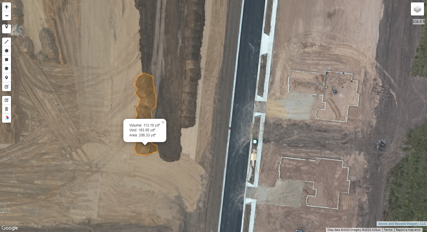
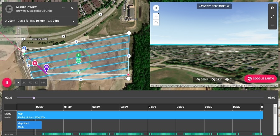
- Orthomosaic Mapping: High resolution ‘flat’ aerial maps that give you the full “bird’s eye view” of the construction site and can be used to perform stockpile volumetric estimates.
- Some construction areas may be unsafe to traverse, but a drone from the air can see where you may not be able to.
- Observe any work hindrances in the build project.
- Time-Lapse Imagery: We capture still imagery from the same location each time we fly. These can be used to create time-lapse presentations that go a long way to impress current clients as well as those you market to at a later date.
- Monitor construction phases or plan potential changes.
- Meet insurance coverage requirements and document the work site for claim processing.
- Future marketing goals: Show investors past projects from start to finish.
- Documentation: For records and historical archives.
Construction Site Monitoring: Our Services
Above and Beyond Imagery’s construction site monitoring services are as follows: photography, videography, and orthomoasic mapping. We can provide any combination of those services as requested.
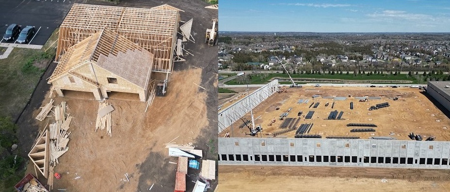
Basic Aerial Still photography: The basic drone service for constriction site progress monitoring. We will fly both automated and manual flights around the construction area to capture still photos of the site. Have specific areas you want captured, just let us know. All photos are high resolution. (see our sample page here)
Videography: We will fly both automated and manual flights around the construction area to capture video of the overall site. Just like with still photography, if there are specific areas that need more attention, just let us know. All videos are 4K. (see our sample page here)
Photogrammetry/Orthomosaic Mapping: Orthomosaics can be used to give an overall view of the entire construction site, provide a means of relative accuracy for measurements, stockpile volumetric measurements, and more. (click here for more information on our drone mapping service)
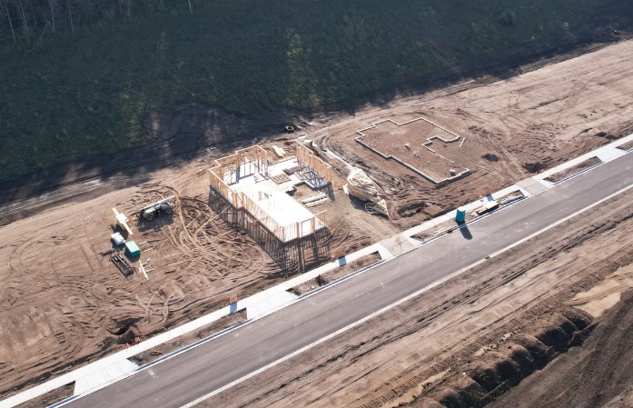
Our automated flights mentioned above fly the same altitude, course, and capture the same location based imagery each time the flight is performed (unless adjustments are needed over the course of job progress). This allows for image and video continuity and faster visual progress recognition when reviewing various flight data over a period of time.
Our manual construction site monitoring flights can vary from flight to flight, capturing various stills and video from different locations around the construction site as needed and requested.
Pricing For Construction Site Monitoring
Our construction site progress monitoring pricing is calculated based on the time it takes to perform the data capture being requested. The overall time being billed includes performing the drone flights as well as office time involved pre and post flight in order to make the collected data deliverable to the client.
We can fly daily, weekly, bi-monthly, or monthly – pretty much as needed weather permitting. Most drone construction progress monitoring flights are flown about a week apart, roughly four times per month. If you need us to fly more often than that, discounts rates are applied.
How To Get A Quote
Getting a quote for our construction site monitoring services can be done in three easy steps.
- Above and Beyond Imagery can provide a per flight estimate for any construction site of any size. In order to do so we would need to know what flight services you are most interested in; photography, videography, orthomosaics, or any combination of those three.
- Next, if possible, we would like to visit the job site and fly a drone through several flights to do data test capturing – there is no charge for this initial visit or for any aspect of our quoting process.
- We provide a quote once the construction site has been assessed and any questions we have are answered. This can usually be done within 48 hours, weather permitting.
If for some reason we are unable to visit the job site (weather, current/temporary access limitations, etc…), we can potentially provide an estimate using information collected from satellite imagery and running drone flight simulations from our office. However, such estimates may need to be fine tuned once access to the job site is attainable to nail down a solid quote.
To request a quote please contact Above and Beyond Imagery by clicking here: Contact Page.
Construction Site Monitoring: Deliverables
Deliverables are the results from the drone flight that are to be delivered to the client. Above and Beyond Imagery provides two methods for customers to receive their deliverables from our construction site progress monitoring flights.
Private Cloud Access: Customers will have specific file access to our cloud server where they can download all images, videos, and orthomosaic maps. Each flight will be placed in its own dated folder and is very easy to manage and download. Private cloud access is a standard service and cost nothing extra.
Private Website Access: For an additional cost a private access website can also be available to view all the collected imagery from each specific construction progress monitoring flight. The website can be public or it can be private access protected (password login required).
The website is an excellent way to showcase the project and share it with anyone in the need to know. It can also be used as a marketing tool for future projects. At the end of the project the website remains in place for up to six months, or longer upon request (for a nominal fee).
WEBSITE SAMPLE: To see a sample of what website deliverables can look like, click here to check out our sample website page.
Construction Site Monitoring Disclaimer
While Above & Beyond Imagery is capable of aerial data collection, contractors and project managers should know that we do not provide or interpret survey grade information. For projects where exact measurements count you still need to rely on a licensed land surveyor/survey engineer. Above and Beyond Imagery can provide data in cooperation with your surveyor, but our data gathering does not replace the need for a licensed land surveyor in any state. This is not exclusive to our business, all drone data collection services cannot interpret at an absolute accuracy data level unless they have a surveyor on staff.
Above and Beyond Imagery is available to work with licensed surveyors as requested.
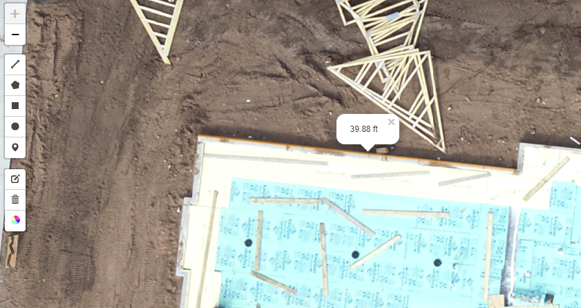
Image below: Orthomosaics can be zoomed in for closer detail inspections and to take relative accuracy measurements. The outside wall being measured is in fact 40 feet, however, as an example of ‘relative accuracy’, the drone orthomosaic shows 39.88 feet. More information on ‘relative versus absolute accuracy’ can be found on our orthomosaic drone mapping service webpage.
Request Our Construction Site Monitoring Services
If you want to contact Above & Beyond Imagery and discuss the possibility of having your construction project monitored with aerial imagery, please reach us through our ‘CONTACT’ page.